
The Vitals
Dates: June 8 – June 14, 2017
Location: Kluane National Park – Donjek Range
Partners: Brittany
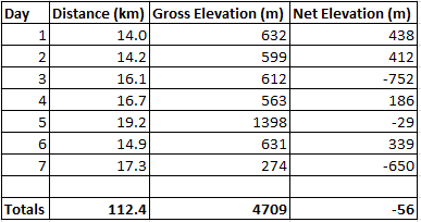
Distance: 112.4 km (4709 m gross elevation, 2157 m highest point)
Time: 7 days
Resources: National Parks site for route description, this blog post
Our food packing list: Yukon 9 Day Meal Planner
Photos: Brittany
GPS Tracks: See below
The Trip
Pre-trip
During our bike tour of the Golden Circle we had already sussed out many of the logistical issues related to hiking the Donjek Route. One of the biggest things we needed to prepare was our mapset. The 1:50 000 maps available for the area were $10 each but the route covers areas on five different maps. Rather than buy and carry all of the maps, we downloaded them and then Brittany used photoshop to cut out just the areas we needed. We printed them at the UPS store in Whitehorse for a total of $12 on 11×17 paper which mostly preserved the size and was more than adequate resolution on the densest maps.

Since we didn’t have a car, our plan to reach the trailhead was to hitchhike from Whitehorse to Haines Junction on the afternoon before we started hiking. In the morning we would hitchhike again from Haines Junction to the start of the route at the Duke River, about 10 km north of Burwash Landing. If we arrived early enough to Haines Junction (before 7:00 pm) we could take care of our permits and pick up the bear canisters.
We quickly got a ride from the top of Two Mile Hill to the junction of highways 1 and 2 just out of town. From here we waited to catch someone heading all the way to Haines Junction. We didn’t have long to wait before a big Dodge camper van stopped and we hopped in. The driver, Simon, is a daily youtuber who has been living in his van for the last 18 months. He wanted to head to Dawson, which is north of Whitehorse on Highway 2. About 130 km in to the 150 km drive to Haines Junction west on Highway 1 I think it was beginning to dawn on Simon that he had made a navigational error (see his video on it).
Arriving in HJ around 6:00 pm, it was early enough to check in with the park. There hadn’t been any attempts on the route yet this season so there weren’t any current reports on trail condition but Brittany and I had long since committed to giving it an attempt. We could always turn back at the mountains if snow became an issue. Before the addition of the bear canisters and extra water, our loads were already a total of 90 lbs – more than a third being food – but there was little opportunity to pare that down. We paid for backcountry permits for five nights as we planned to spend another two nights outside the park boundaries. At about $10/person/night it worked out to $100 plus the $200 deposit for two bear canisters.

By the way, if $50/person in permits sounds too cheap, you can pay over $3000 to be guided on this route…
Day 1 – Duke River trailhead to 14 km up the road (14 km total)
Given the long days, we were not in a rush on our first morning to start hiking. We had stayed at the Wanderer’s Inn hostel the night before and ate Ramen for breakfast and some pie at the bakery before walking out to the road junction around 11:30 am. We only needed to wait about 30 minutes before another solo camper van picked us up. This driver was a retired Ohioan putting in 400 – 500 miles per day so our company for about 130 km was welcomed. He dropped us off at the side of the highway at the Duke River after both complimenting our generation on gender equality and expressing incredulity that Brittany could like bushwacking given that she’s a girl. It’s a hard concept, but if that isn’t the definition of irony…
The first day was spent entirely on old mining roads that climb from next to the Duke River up into the tundra. After about 5 km you reach an old horse camp but there also appeared to be some newer structures and a modern excavator working on the road, though we saw no one as we passed by. In fact, the driver from Ohio was the last person we would see other than each other for the duration of the hike.

At the horse camp the route wasn’t very well defined but we turned right, away from the Duke River, and began hiking up quite a steep hill. Within a couple of kilometers we took a branch to the left and the grade lessened all the way up into the tundra. There was less water available on this section of trail than we expected so we had to bushwack our way down to a lake and back to fill our bottles with some very still, yellow water.
Once in the tundra there is no relief from the sun and I was surely dehydrated after 14 km and I had long since ceased to sweat despite the high temperatures. As soon as we decided to make camp at a small snow-filled creek, I set up the tent and passed out for an hour. When I woke up I drank a liter of water and then slept for another half hour before I felt normal enough to emerge from the shade of the fly and watch Brittany cook dinner. It was about 9:00 pm but the sun was still intense enough that we looked forward to getting back in the tent to sleep.

Day 2 – Kilometer 14 to the base of Hoge Pass (14.2 km, 28.2 km total)
I woke up to Brittany opening the fly and excitedly pointing at some animals out of my line of sight. I poked my head out and we watched three caribou trot across the tundra. Surprisingly, caribou seem very curious and kept coming closer and closer to us and the tent, seemingly fearless. Eventually they decided we were harmless and carried on out of sight.


We packed up and resumed progress north of Amphitheater mountain for about 7 km, scaring many ptarmigan along the way, until the mining road abruptly ends. At this point the route description says to beeline across the tundra to a “low saddle” northwest of Ampitheater. There were a few to choose from and without trees it is hard to gauge distance. We picked a likely candidate and squelched through the hummock. From afar the ground looks dry and smooth, probably because of the yellow grasses, but it is actually a saturated mossy covering that you sink into about 6 inches every step. This makes it tough work but the entire section to Burwash Creek and our first creek crossing only lasted about 2 hours and featured more curious caribou (three young ones and a mother).

After crossing Burwash Creek we headed upstream for a couple of kilometers past the currently empty warden patrol cabin. We had evidently crossed the park boundary but had cut the corner a little too aggressively and had missed the signs as well as given ourselves an extra hill climb. We weren’t yet tired so we walked one extra kilometer to the base of another old road that leads to Hoge Pass, our goal for the next day.


We enjoyed dinner next to a small creek surrounded by wildflowers and the constant squeaking of the arctic ground squirrels. After dinner we took a side trip further up Burwash Creek to discover an impressive wall of rock easily 40 feet tall with a three foot wide crack carved down the middle by the stream. This wall spans the narrow valley and I wouldn’t be surprised to learn if it once dammed a lake at the toe of the Burwash Glacier. It was tempting to jump across the chasm to the other side but we decided an adventurous scramble down the wall was the safer option.

Day 3 – Base of Hoge Pass to 4 km up the Donjek river from the Hoge Creek/Donjek junction (16.1 km, 44.3 km total)
Now out of the tundra, we walked on supportive rock and gravel up to the pass following the faint old road where we could see it. Near the saddle we discovered that quicksand exists outside of cartoons when some solid looking dirt swallowed my boots and refused to let go. This resulted in a loss of balance and getting covered with mud before gracefully wallowing to the edge on my stomach.

At the top of the pass the description recommends traversing as left as possible before descending and gives a vague description of what you can expect to see. I think we took the “as left as possible” to heart and managed to get very high above one of the tributaries of Hoge Creek before descending loose, steep scree past a waterfall and several mountain goats. It was loose enough that occasionally the flow of stones would simply pick up momentum below you in a miniature landslide and you would step off to the side and let it run its course before reentering. This would be slow going if you are uncomfortable with scree skiing or if you have a large group since you can only descend one at a time to prevent raining down rocks on your partners.

At the bottom we ate lunch next to the tributary before continuing down to the main part of Hoge Creek. The creek cuts its way through some canyons for a few kilometers, which necessitated numerous crossings (about 15 in our case), before opening up into a much wider and flatter drainage for the last few kilometers and eventually emptys into the Donjek river. Due to the crossings, we hiked 10 km or so in our sandals which was surprisingly comfortable. At times we waded through sections of knee-deep and ice-cold water but at other times we were able to cross on snow bridges left over from last winter. In the tightest canyons I could imagine that the creek would become dangerous to cross in higher water levels. These were mostly in the sections just after we finished our descent from Hoge Pass and its possible that our routefinding difficulties put us in a position that is usually avoided.


Once at the Donjek river we started to catch our first glimpses of the Donjek glacier about 15 km upriver. This river is another example of a fairly small watercourse in a huge valley. This allowed us to walk on its east side on flat and well-sorted river rock rather than in the trees. Although small compared to the valley, crossing the Donjek on foot looked at best dangerous and at worst impossible. From earlier in the day, Brittany had noticed some large patches of purple in the middle of the gravel. As we got closer to these patches, the smell of wildflowers was almost overwhelming, as strong as any flower shop. The trek was becoming a 5-sense experience.


We made camp on the flat stones and cooked dinner. As we went to bed around 11:00 pm the wind began pummeling our tent and it was becoming apparant that our exposed tenting spot had been a mistake. We got out of bed and carried the assembled tent with our sleeping stuff inside across the valley bottom to a small rock outcrop which acted as a windbreak. This was no easy feat in the gusts but the relative calm behind the outcrop was a blessing for sleep.


Day 4 – Donjek River camp to just north of Bighorn Creek (16.7 km, 61 km total)
After breaking camp we started to walk further upriver towards the Donjek glacier along the valley bottom. After only a few hundred meters we realized we were about to be pinched between the impassable river and some cliffs. We bushwacked up the bank into the forest where the route description said we would spend about 45 minutes at most before finding a horse trail which we could follow parallel to the river. At some point we found a dry creekbed (the one with pink-coloured rocks as described in the route description) and it was easier to walk up this than bushwack in the forest. Unfortunately we didn’t spot where the horse trail crossed the creek from within it and we ended up climbing up much higher than anticipated. When it was clear we had already crossed the trail, we recommenced bushwacking up river while slowly descending until we happened upon the trail after a few kilometers.

Once on the horse trail we no longer had to make routefinding decisions but it is only a faint trail, not a highway. The next 6 kilometers continued to be a bushwacking hell until we were spit out in a meadow just across the river from the glacier. On the map you can see that this glacier winds its way for kilometers up a valley and joins many others in a spectacularly expansive icefield but from river level you only catch a small glimpse of this system. Also, despite the previous three days of bright sunshine, this day was overcast from the outset albeit without rain.

As we continued past the toe of the glacier we discussed our strategy for the next day. From the outset we had intended to take the alternate route to Atlas Pass via Expectation Pass rather than hiking all the way to Bighorn Creek. This route has some extra elevation gain but also reportedly had better views of the aforementioned icefields and peaks of Kluane. With this plan in mind, we camped a few kilometers north of Bighorn Creek near one of the myriad other creeks. Remembering our previous battle with the wind, we selected a sheltered and flat tent site and bathed in one of the creek braids while listening to wolves howl and yip somewhere nearby.


Day 5 – Bighorn Creek to the Duke River (19.2 km, 80.2 km total)
Waking up here and there in the middle of the night already told us that it had rained but it wasn’t until we popped out of the tent that we received two pieces of bad news. First was the sight of fresh snow on the previously barren Expectation Pass. Second was that bear canisters are emphatically not rain proof – anathema to dried food. After inspection we discovered that the majority of the food was unscathed and the snow appeared to only be a dusting. Bad news, sure, but not catastrophic. We packed up the wet tent and headed as directly as possible through the bush to the canyon at the base of Expectation Pass.


From the base it was about an hour to reach the top of the pass, some of this time spent with hands and feet scrambling up the gut of the creek which cuts down the canyon. At the top we reached the patches of fresh snow and also happened upon a group of 14 Dall Sheep. Unfortunately there wasn’t much to see beyond the sheep. The spectacular views we hoped for were obscured by the clouds that were swirling around us and it began to drizzle rain and wet snow.

From just past the saddle we looked downhill to see the drainage we assumed was Chert Creek leading into what was definitely Bighorn Creek. Since we didn’t have a description of the alternate route we had chosen, we weren’t sure whether to descend steeply to Chert Creek and then regain elevation via the main route or if we could keep our elevation and contour left to Atlas Pass through several steep-sided gullies. I had downloaded another party’s GPS tracks before we left and they had contoured so we decided on the same. A combination of billy goat trails and gps track-following got us through the steepest gullies and spit us out in a zone of tiny hills made of black rock and moss. In many places the moss was a thick carpet on top of these rocks but as you walked across it you could feel the fist-sized rocks through the moss shifting and settling under your weight.

This was the site of our proposed campsite but the flurries and rain had transformed into true snow and the patches of fresh snow had built up into a uniform covering a few centimeters deep. It was decision time; we could spend the night in a wet tent in the snow and hope it didn’t accumulate too much, or we could soldier on over Atlas Pass and descend to a much lower elevation where snow was less likely and possibly a rain shadow would mean drier camping. Really, it was an easy choice.
At the top of Atlas Pass we stared down the extremely steep and snowy far side. This is not the recommended descent, rather you turn left and head up a little higher to the route’s high point (2157 m) before descending to “Hole 9” and a different creek drainage which becomes Atlas Creek and eventually meets the Duke River, upriver of our start point, 6 km later.


We survived the descent through extremely soft dirt and quickly dropped below the snowline on our way to Atlas Creek. The plan was to camp any time once we were below snowline but since it was raining and we were already wet, we simply continued all the way to the Duke River where we changed clothes as carefully as possible and cooked in the tent’s vestibule before falling asleep to the pitter patter of continuing rain.

Day 6 – Atlas Creek/Duke River to Cache Lake (14.9 km, 95.1 km total)
We were now sure to finish in 7 days rather than 9 so double chocolate rations and extra snacks helped our moods as we packed up in the rain and wet snow that had accumulated through the night.

With all of the mountain passes behind us, there remained in our minds one final true obstacle to finishing the trip: crossing the Duke River. This crossing is impossible where Atlas Creek empties into the river but only a few kilometers upriver the valley gets much wider and the river braids into a half dozen or more parallel flows.
Reaching this point in the valley was not physically challenging but given the rain, the snow-covered foliage, and the current course of the river, we were forced to wallow through bog and heavy vegetation for most of the distance, getting soaked to the bone in the process. Being so cold already, we agreed that it was only reasonable to cross the river once and once we were across we would commit to bushwacking as necessary if it meant that we could avoid entering the water again.
The crossing, while cold, was made easy by a lower flow than expected and the numerous braids. Once across we found ourselves in another boggy area formed by a steep-sided mountain next to the river. Committed to our plan, we started ascending the hill in hopes of finding some drier ground. It was not to be and we spent over an hour making poor progress in the bushes. From one small clearing it looked as if the sun was coming out and that there was now space on our side of the river to walk on the gravel so we gave up all of our elevation and returned to the river bank. We started to boil water for hot chocolate and ate crackers in the sun but just as quickly as it arrived, the sun was swallowed by the cloud and the rain and snow returned harder than ever.

The next two hours were the most miserable hiking I have ever done. Still soaked and cold from the river crossing and the snow, I then guided us quite far off route because I misremembered the directions and didn’t want to pull the maps out in a storm. Instead of following a creek drainage straight up to Cache Lake, I instead brought us an extra two kilometers through a slippery, boggy forest choked with vegetation and deadfall at a glacial pace . Over and over we would gain ground just to be forced downhill again by one obstacle or another. My jaw was sore from clenching due to the cold and shivering. Both our minds swirled with the dark fantasies of one or the other of us twisting an ankle in terrain that was wholly unsuitable for stopping in. There was nowhere to pitch a tent, the tent was wet anyways, and we were freezing. It was a “too many lemons” situation – one where a combination of factors, none too serious on their own, can devolve into an emergency.

At last we popped out at the top of the hill and began to see signs of another old mining road that would pass by our goal for the night: Cache Lake. All told a “short” 12 km day had turned into 15 km and taken nearly 10 hours.
Too tired and cold to bother cooking, we set up camp a few hundred meters from the national park boundary on a tiny patch of flat dirt next to a small creek.

Day 7 – Cache Lake to Hwy 1 at Copper Joe Creek (17.3 km, 112.4 km total)
The small creek we had pitched beside was actually the very start of Copper Joe Creek. This creek makes its way downhill from Cache Lake and crosses the highway and would be our guide out of the bush and back to civilization.

While straightforward in terms of routefinding, the last day was still difficult terrain to travel. At times the old road is well-defined enough that you can quickly hike a few hundred meters but it always disappears again and the bushwack resumes. It is impossible to determine which side of the creek is preferable to travel on most of the time, so we eventually decided that we were done with creek crossings and we would commit to the south/east until the bitter end. As the creek country became canyons, this choice entailed some easy bouldering traverses along the cliffs where the creek ran up against the sides of the canyon.

We also were treated to a close encounter with a mother and baby porcupine. Porcupines may not be the most protective mothers since the adult ran/waddled into the bushes and out of sight immediately, leaving the baby to fend for itself. The baby’s strategy was to climb a tiny tree showcasing adorably little skill. After a few photos we left the baby alone and discovered the mother returning to the scene presumably to pick up her little one.

About 4 kilometers before the highway a road in great repair appears and, with packs about 30 lbs lighter than when we started, we nearly flew down the last hills with views of Kluane Lake across the highway.

About an hour of hitchhiking later (a.k.a. a dozen cars) we were picked up by a lovely couple, John and Irene, who we would end up spending the night with and they returned us to Whitehorse the next day. After 7 days of hiking and positively identifying grizzly tracks every day but with no sightings, we were finally treated to a young sow grizzly feeding near the northern park office. John pulled over so we could watch for a little while and it was a fitting end to a long hike in the North.


You must be logged in to post a comment.